Poster Printer for Schools Mountain Learning
The Power of Place-Based Education
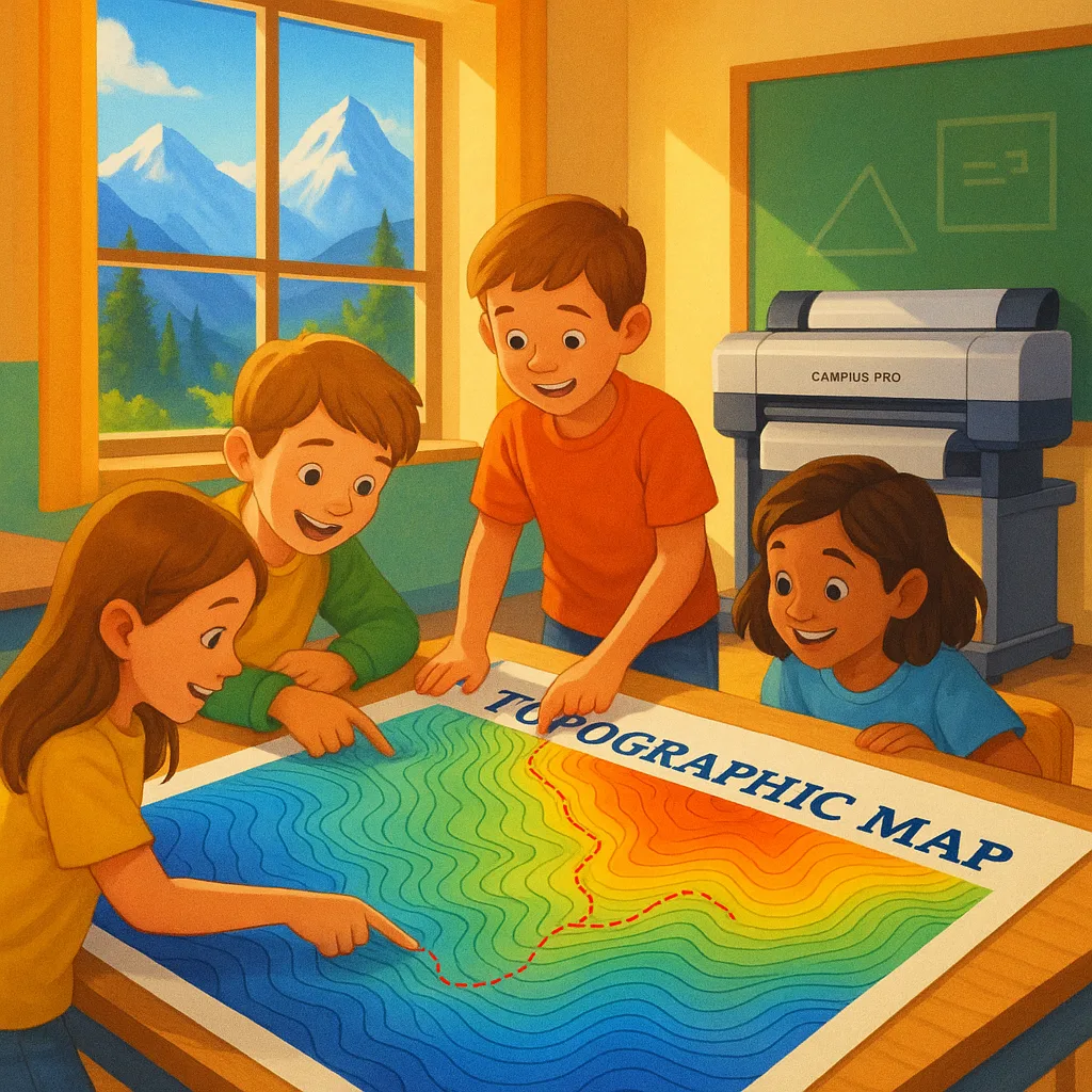
Place-based education isn’t just a buzzword in mountain state schools—it’s a transformative approach that connects students to their immediate environment. When teachers use a classroom poster maker to create large-format topographic maps, they turn their local landscape into a living laboratory.
Sarah Mitchell, a 5th-grade teacher at Eagle Peak Elementary in Colorado, explains how this approach changed her geography lessons forever. “Before we started creating our own topographic posters, students struggled to understand contour lines and elevation changes. Now, they can point to the exact ridge they hiked with their families last weekend and trace the elevation profile with their fingers.”
This tactile, visual approach makes abstract concepts concrete. Students don’t just memorize facts about watersheds—they see exactly how the snowmelt from their local peaks feeds the streams running past their school. They understand climate zones not as colored bands in a textbook, but as the actual transitions they observe driving up the mountain road.

Creating Custom Topographic Teaching Tools
The process of creating custom topographic posters begins with understanding what makes mountain geography unique. Teachers in these regions face specific challenges: explaining avalanche zones, demonstrating how altitude affects ecosystems, and helping students grasp the three-dimensional nature of their landscape.
Using tools like the Campus Pro 44 Poster Maker Elite Package, educators can produce stunning 44-inch wide terrain maps that capture every ridge and valley. The water-resistant pigment inks ensure these teaching tools withstand years of hands-on exploration by curious students.
Mike Rodriguez, who teaches earth science at Mountain View Middle School in Montana, describes his poster-making process: “I start with USGS topographic data for our local area. Then I layer in additional information—hiking trails the kids know, historical sites, even the locations of recent wildlife sightings. The result is a map that’s both scientifically accurate and personally meaningful.”
Essential Elements for Mountain Maps:
• Elevation contour lines
• Local watersheds
• Trail systems
• Historical landmarks
• Climate zones
• Wildlife habitats
• Geological features
Poster Printer for Schools Topographic Success Stories
Student engagement increase with visual terrain maps
Schools now using topographic poster programs
Better retention of geographic concepts
Average cost per custom 36″ terrain poster
Integrating Climate Science Through Elevation Studies
Mountain state educators have discovered that topographic posters serve as powerful tools for teaching climate science. By visualizing elevation changes, students can literally see why temperature drops as altitude increases and understand how this affects local weather patterns.
Jennifer Chen, who leads the science department at Alpine Regional High School in Utah, uses a poster printer for schools to create layered climate zone maps. “We print transparent overlays showing temperature gradients, precipitation patterns, and vegetation zones. Students can stack these over our base topographic map to see how elevation drives our local climate.”
This multi-layered approach helps students understand complex interactions. They see how mountain ranges create rain shadows, why certain elevations support specific plant communities, and how climate change affects different zones at varying rates. The visual nature of these lessons makes abstract climate concepts tangible and memorable.
Local History Comes Alive
Beyond science applications, topographic posters excel at bringing local history to life. Teachers overlay historical events onto terrain maps, helping students understand why settlements formed in certain valleys, how mountain passes influenced trade routes, and why battles occurred at specific elevations.
The Amplify Poster Maker with its scan-to-poster capability allows teachers to digitize historical maps and combine them with modern topographic data. This creates compelling before-and-after visualizations showing landscape changes over time.
Teaching Tip #1
Use elevation colors that match local vegetation zonesImplementation Strategy
Start with a base map showing natural elevation colors, then add vegetation overlays that correspond to what students actually see on mountain hikes. This creates instant connections between map symbols and real-world observations.improved test scores in geography after implementing topographic posters
Practical Implementation Guide

Step-by-Step Creation Process:
1. Gather Data: Access USGS topographic data for your region
2. Customize Content: Add local landmarks, trails, and points of interest
3. Choose Scale: Select appropriate scale for classroom visibility
4. Add Layers: Include climate, vegetation, or historical overlays
5. Print & Laminate: Use water-resistant materials for durability
6. Create Activities: Design hands-on exercises using the maps
Budget-Friendly Tips:
• Start with one large regional map before creating detailed local versions
• Use funding sources like Title IV for STEM integration
• Share costs between grade levels for multi-use maps
• Consider the printing costs for different media types
• Laminate popular maps for extended use
Cross-Curricular Applications
The versatility of topographic posters extends far beyond geography class. Creative teachers across mountain state schools integrate these visual tools into diverse subject areas.
Mathematics
• Calculate slope angles
• Measure map scales
• Graph elevation profiles
• Compute watershed areas
Language Arts
• Write trail descriptions
• Create place-based poetry
• Research local legends
• Document oral histories
Physical Education
• Plan hiking routes
• Study altitude training
• Map ski areas
• Design orienteering courses
Art & Design
• Study landscape forms
• Create relief sculptures
• Design trail markers
• Paint from elevation views
Teacher Testimonials: Real Impact in Mountain Classrooms
“The first time I unrolled our custom watershed map created with our classroom poster maker, the room went silent. Students immediately started finding their homes, favorite fishing spots, and hiking trails. That engagement lasted all year long.”
– Rachel Martinez, 4th Grade Teacher
Rocky Mountain Elementary, Colorado
“Our geology unit transformed when we started printing 3D-effect topographic posters. Students can visualize fault lines, understand erosion patterns, and predict landslide zones. It’s hands-on learning at its finest.”
– Dr. James Wilson, Earth Science
Mountain Vista High School, Wyoming
Essential Equipment for Topographic Printing:
For schools serious about place-based education, having the right poster printer for schools makes all the difference. Consider these factors:
• Print Width: 36-44 inches for full watershed visibility
• Ink Type: Water-resistant for outdoor field use
• Media Compatibility: Handle various paper weights
• Color Accuracy: Critical for elevation gradients
The Campus Pro 36 Advanced Package offers an ideal balance of size and capability for most mountain region schools.
Looking Ahead: The Future of Place-Based Education
As technology advances, the possibilities for topographic education continue to expand. Schools are experimenting with augmented reality overlays on printed maps, QR codes linking to local wildlife webcams, and student-created story maps documenting community changes over time.
The foundation, however, remains the large-format printed poster—a tactile, collaborative space where students gather, point, discuss, and discover. Whether tracking seasonal changes, planning conservation projects, or simply understanding why their town exists where it does, these visual tools connect classroom learning to the world right outside the window.
For mountain state educators, investing in a quality poster printer for schools topographic capabilities isn’t just about creating teaching materials—it’s about fostering a generation of students who truly understand and care for their unique mountain heritage. Through the power of place-based education and visual learning, abstract concepts become concrete realities, and students develop a deeper connection to the remarkable landscapes they call home.